Cycling from Toronto to Montreal
A tale between two cities.
by Theresa Wallace

Canada’s two largest cities are connected by more than four-lane highways. The back roads and paths linking Toronto and Montreal form a network that allows cyclists to make the trip from one urban centre to the other. If you’re a seasoned on-road cyclist, bike it alone or with friends on a completely personalized sightseeing route. If you’re a recreational cyclist who feels less confident about striking out on your own, check out an organized tour. Or sign up for a fully supported fundraising ride and make new friends along the way. Whichever way you decide to travel by bicycle between Canada’s two largest cities, it’s a journey worth taking.
“There are many natural beauty highlights along the way,” says Torontonian Linda Stewart, “but the most wonderful part of the trip is simply discovering you can do it. You can ride your bike between Canada’s two largest cities and feel better and stronger at the end than when you started.”
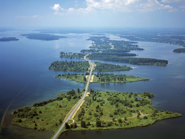
The route
The Toronto-to-Montreal cycling route generally follows waterfront – first Lake Ontario and then the St. Lawrence River. The trip is at least 600 km and may be as long as 660 km depending on exactly where you start and finish, plus how far you venture off the Waterfront Trail in Ontario and the Route Verte in Quebec. The prevailing winds during the warmer months are from the southwest, so cyclists can count on enjoying a tailwind at least some of the time. The riding consists of roughly equal measures of on-road cycling in some traffic, off-road pathways and cycling on quiet roads. Most, but not all, of the Waterfront Trail is paved, so it’s most suitable for hybrid or touring bikes; although, cyclists on road bikes often follow the trail and make detours to avoid any muddy or gravel sections.
The Waterfront Trail website (waterfronttrail.org) lists the main Toronto access points to the trail with parking and includes route maps. To plan where you’ll dismount in Quebec, you can use the Route Verte (routeverte.com) trip mapping function.
Challenges and highlights
On the Waterfront Trail, there are some undeveloped sections at the top of the Scarborough Bluffs in Toronto’s east end. Cyclists should also exercise caution at a busy section of roadway with no paved shoulder on the east side of Oshawa, Ont. It’s also a bumpy ride on the deteriorating Thousand Islands Parkway off-road paved path for 37 km between Gananoque and the cottage community of Butternut Bay, about 12 km west of Brockville. Finally, the lack of paved shoulders on County Road 2 between Maitland and Iroquois detract from the visual delight of the St. Lawrence River on your right.
Brockville mayor and cyclist Dave Henderson has done the Great Waterfront Trail Adventure from Niagara Falls to the Quebec border and admits some parts of the ride that are on roads with no paved shoulders are less than comfortable. “But in the United Counties of Leeds and Grenville, for example, there are 13 different government entities with jurisdiction covering a relatively small area,” Henderson says, “so co-ordination in the interests of having more paved shoulders is a challenge.”
Cyclists report the highlights of the ride include Thickson’s Woods, which is the last remnant of old-growth white pine forest on the north shore of Lake Ontario near Whitby, gorgeous scenery through Prince Edward County, a picturesque off-road stretch from Morrisburg to Cornwall and great riding on the Route Verte. The St. Lawrence Parks Commission operates sites alongside the Waterfront Trail from Kingston to the Quebec border, including 12 campgrounds and day-use areas, so there are a lot of opportunities for swimming, picnics and camping in this 200-km stretch. Although cyclists complain they have to pay the same amount of money for a campsite at St. Lawrence Parks as do those driving motorized vehicles, Darren Dalgleish, general manager and CEO of the commission, says there is also an informal policy at many St. Lawrence Parks campgrounds that cyclists will never be turned away even if the campsite is full.
Fine-tuning your trip plan
If you’re a fearless on-road warrior ready to handle surprises such as road construction and traffic, you may not need to do much planning. But if you are looking for a laid-back, self-directed trip, Hal Cain, tour director of Velo Kingston, suggests you consult local bike clubs along the Ontario portion of your route in advance of your trip because they know the best cycling in their areas. “Get as much information as you can, and personalize your route based on what you want to do and see,” Cain advises. (For example, Alan Medcalf, chair of the Brockville cycling advisory committee, says local cyclists travelling east out of Brockville often take concession roads north of Highway 401 to avoid the traffic and unpaved shoulders on Country Road 2.)
Information on bicycle-friendly accommodation and businesses on the Ontario portion of the route is available on the Welcome Cyclists Network website (welcomecyclists.ca), a program offered by Transportation Options, an Ontario-based non-profit sustainable tourism and transportation organization, and on the Route Verte website for Quebec. Once in Quebec, it should take no more than a day to reach Montreal. The reward once you get there is spending a couple of days touring on the city’s extensive cycling network.
Getting your bicycle back to Toronto requires some planning. You can bring your bike back by rail if the Via Rail train you take has a baggage car. During the summer months, baggage cars are equipped with bike racks and if space is available no boxing or pedal removal is required. For more information, check out viarail.ca/bike.
Why bother riding between Toronto and Montreal? “In all of our living, we rush,” says Marlaine Koehler, executive director of the Great Waterfront Trail Adventure. “A bike ride along waterfront activates your senses at the same time as it forces you to slow your pace. Spending a week of your vacation riding between Canada’s two largest cities is a great way to get to know some of the most beautiful natural parts of two provinces while visiting their vibrant small towns.”
One wrong turn
Tandem cyclists Hélène Lortie and Josée Pelletier, who were biking to Montreal as part of a much longer journey, missed one turn of the Waterfront Trail and some warning signs and ended up on Highway 401, one of the busiest highways in Canada. “That experience was one of the most traumatic of our trip because the portion of the highway we were stuck on had a 12-inch shoulder and the traffic was very dense. We did not breathe for the 2 km we were on 401 and once we could get off, we were shaking and almost threw up our breakfast,” says Lortie.
The missed turn is just past the eastern end of the off-road paved path that parallels the Thousand Islands Parkway. At the end of the path, you need to turn right from the parkway onto Brockmere Cliffs Drive. If you miss this turn, you continue on a road that, unfortunately, turns out to be a ramp onto 401. Lortie and Pelletier soldiered on and completed their journey from Vancouver all the way to their homes in Quebec, raising $10,600 for Autisme Québec.